Foundation documents.
00 – Cover Page
Get Maps from the site
02, 03 – Site Analysis
09 – Demolition
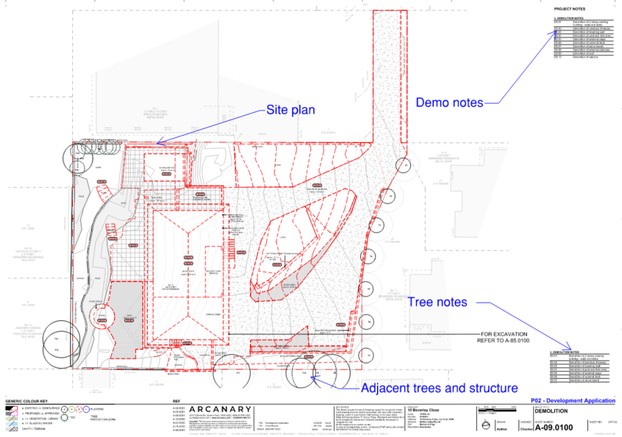
Demolition Plans fall under the A-Term (Analysis) and are essential for describing the condition of the site before construction begins. Subset 09 – Demolition outlines the removal of existing structures, elements, or vegetation, and defines what is to be retained, restored, or made good.
Checklist
GENERAL
- Plan uses existing conditions base (from Subset 08)
- Correct sheet number and subset code (09) are applied
- North point, scale, and title block are present
- Project-specific demolition notes are placed on the sheet
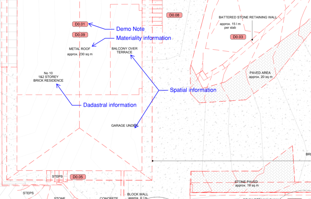
SITE AND CADASTRAL INFO
- All involved lots and street numbers are shown
- Lot and DP numbers are included for each lot
- Site boundaries and easements are accurately represented
- Existing infrastructure (e.g., poles, pits, drainage) is shown
STRUCTURES AND MATERIALITY
- Roof materiality labeled (e.g., terracotta tiles)
- Building type described (e.g., double brick, concrete frame)
- Ground surfaces shown and labeled (e.g., grass, paving)
- Approximate areas (m²) are calculated for:
- Building footprints
- Hardscape surfaces
- Landscaped/soft surfaces
ANNOTATION
- Elements to be demolished shown in red dashed lines
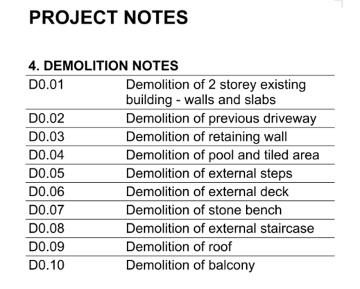
- Notes numbered and tagged on plan (D1.01, D1.02,….)
- Note legend placed on left or right margin
- Descriptions are clear (e.g., Remove wall and make good)
- Areas (m²) shown to envelope and ground covers
- Dimensions included for detailed demolition
TREES AND VEGETATION
- Trees within and adjacent to the site are shown
- Trees are coded to match Arborist Report (e.g., T1, T2…)
- Canopy spread, TPZ, and SRZ are drawn to scale
- Tree schedule is included (code + action only)
- Tree representation is up-to-date with latest arborist info
Purpose
The demolition plan is used to:
- Define what is to be demolished or retained
- Represent materiality, location, and approximate size of elements
- Prepare for construction or renovation by establishing a clear baseline
- Support coordination with consultants (e.g., structural engineer, arborist)
- Generate related documents such as the Waste Management Plan
Typical Use Cases
- Renovations & Additions – Selective removal of internal or external elements (e.g., demolishing a wall, retaining part of a façade)
- Partial Demolition – Where heritage or existing structural elements must be preserved
- Make-Good Works – Surface infills, plaster patching, or finishes reinstatement
- New Construction – Requires full site clearance, including buildings, vegetation, and pavement across all lots
Required Content
1. Site & Cadastral Information
- Street addresses for all involved lots (e.g., 25 South Avenue)
- Cadastral identifiers: Lot and DP numbers (e.g., Lot 7 / DP 20400)
- Existing buildings outlined and labeled
- Location of easements and visible infrastructure
2. Building Materiality & Surfaces
- Roof type (e.g., terracotta tiles, metal sheet)
- Structural type (e.g., double brick, concrete frame)
- Surface types (e.g., paved, gravel, grass)
- Approximate areas (m²) of each surface and building footprint to support the Waste Management Plan
3. Annotation & Notes
- Red dashed lines to show demolished elements
- Demolition notes numbered (D1.01, D1.02,….), cross-referenced on plan (D + Level Code + Note Number)
- Legend on the left or right side of the sheet describing each demolition item
4. Dimensions & Scale
- Dimensions generally not required
- Exceptions: Renovations or detailed demolition where limits of demolition must be clearly marked
- Focus on area (m²), not lengths
Trees and Vegetation
Trees and significant vegetation must be accurately shown, not just within the site but also in adjacent properties if they may be affected by demolition works.
Tree Representation Requirements:
- Show all trees, coded to match the Arborist Report (e.g., T1, T2, T3)
- Graphic symbols must represent:
- Trunk
- Canopy spread (to scale)
- Tree Protection Zone (TPZ) – shown as dashed boundary
- Structural Root Zone (SRZ) – shown as a smaller inner zone
- Do not include tree species—this is covered in the Arborist Report
Tree Schedule:
- Placed next to demolition notes
- Includes: Tree code, location reference, and action (e.g., retain, remove)
Coordination:
- Revisions to arborist reports must be reflected in demolition plans
- TPZ and SRZ must inform demolition scope, especially when near excavation or foundation works
Representation Formats
- Site Demolition Plans – For clearing entire lots or external works
- Level-Based Plans – For internal demolitions per floor
- Elevations & Sections – When vertical or heritage detail matters
Visual Standards
- Red dashed lines and fills for demolition
- Tree canopies in grey outline, TPZ/SRZ in dashed lines
- Use consistent codification for notes and trees
- Place legend and notes consistently on the sheet margin
Samples
New Construction